|
|
||||
Reports on the The Turon Gold Rush |
||||
|
||||
Alexa McAuley Reports ...The NSWRA Autumn Rogaine for 2007 was held in the surroundings of the Turon River in the NSW central tablelands. Following three fabulous April weekends, the weather for the Rogaine weekend took a turn for the wet. Rain was great news to the local landowners, but created some interesting moments for those coming down the dirt road from Capertee way. Thanks goes to the campground manager Soren, and his big ute, who provided help getting trailers and caravans in and out! Rain got heavier throughout the night, but fortunately the camping area surface held up remarkably well and the weather looked promising as Saturday midday approached. “How did we find this place?”Many people asked us this question over the weekend – in the early days we often asked ourselves the same! This was the first course any of the course setters have set, but we had some clear objectives in mind. We were looking for a place with minimal scrub or undergrowth, the potential for a central hash house, pleasant options for families, and of course willing land owners! Those who know Phil and Lex will be surprised to hear that hills didn’t explicitly feature in their objective; that was just a coincidence! We thought west of the Blue Mountains was our best hope for minimal scrub so after some initial scouring of maps some national parks and state forests were identified for a reconnaissance mission. As things looked promising we started approaching land owners and were quickly impressed by their enthusiasm for our event. Thanks to all participants for looking after the course so well - with your assistance the area remains a potential for future rogaines. “Why haven’t you given us a few freebie checkpoints?”Was a question we heard high up on the Western part of the course. Our mission had been to set a course where route selection was not obvious and even the top teams would have to think about which checkpoints to leave behind. Into the mix we aimed for some beautiful scenic checkpoints (to make the climbing worthwhile!) Sounds like we managed to achieve a bit of everything. The looks on the faces of competitors who’d just seen the sun set over the Wolgan Valley made the whole effort worthwhile! For those who want to relive some controls – our experiences of setting a few. 85 – Cattle Gully – set by the girls and where we found all the animals when water was scarce. Almost dropped by Phil as he thought it was unfair to drop down so far only to climb back out. Glad to see it was enjoyed by a few! 69 – Set by all three course setters together. Not found on first vetting attempt and almost moved to the knoll as a result. Kept after Scott decided it was fair game for anyone who made it that far south in the first place 103 – Set by Phil – the mine shaft 100metres away was a scary discovery – glad to see no one fell in! Vetter considered it would be hard to navigate at night – course setters again thought that anyone who’d made it that far south might need a navigational challenge to slow them down a bit 61 – Set by Phil. Flag not hung on first attempt due to fog descending on Belinda. Glad the fog stayed away for the event. 93 – Our favourite checkpoint – what sensational views to the Blue Mtns. 101 – out of the way, yet our favourite spot on the Turon River and we thought you should enjoy it, too. A few apologiesFor all those expecting the road in the North West to be a good quality fire trail, we apologise. While we did note that ‘tracks’ varied from ‘fire trails’ to ‘fire breaks’ we realise we should have specified which ones were the fire break quality. This contributed to the 8 hour teams being late and was no doubt a bit of a rude shock to other teams also. Apologies also to the teams that waited for assistance at water drops or were disappointed at the food remaining at the all night café. Our limited resources were directed to locating the late 8 hour teams and we were late in setting out on the midnight water drop patrol. We hadn’t forgotten the 24 hour competitors, but couldn’t be everywhere at once. We finally held a presentation for the 8 hour event on Sunday lunch time. This was a bit late for many competitors who had already headed home, but if you placed we will send your certificate in the mail. We won’t put any more of those red XXXL shirts in the mail, unless there are special requests! And some words of thanksAn enormous thank you to Trevor Gollan, Scott Hamilton,
Phil Allen, Ted Booth, Peter Watterson, Maurice Ripley and
Michael Watts in the Hash House for looking after all aspects
of catering and providing scrumptious munchies. Thanks also to
the All night café team, including Andrew Palmisano, David
Green and Dayle Green, for being self sufficient all night. Thank you to Michael and his vetting team for their perseverance when tape fell off, helpful suggestions and understanding. Thank you to all the participants for coming to our event, sharing your feedback, being patient when difficulties struck and having such big grins out on the course! And the final, biggest thank you to the land holders for letting us share their scrub-free, steep and picturesque land. What happened with the NavLight?Since the last use of the NavLight system by NSW, changes were made to the program used to link NavLight with the NSWRA database. Unfortunately, there were some issues with the code which meant that the program did not correctly read the NavLight of some teams (often the high scoring ones). This issue only became evident towards the end of the 8 hour event, resulting in significant delays to determining the results. Interim results were published based on a combination of NavLight and Cards for the 8 hour event. The organisers apologise for the confusion this caused and also the subsequent delay of the 8 hour presentations. As the 24 hour event was expected to record larger scores, the admin team reverted to using control cards for determining the 24 hour results, enabling the presentations to commence 45 minutes after the finish. However – the NavLight data is not lost. Each team’s tag identity has been retained and Graeme Cooper hopes to have the splits results available shortly. What happened with the search for the 8 hour teams?Many people have been asking about the two teams that were missing after the 8 hour event, and we're pleased to report that they were found safe and happy on Sunday morning. Their absence some hours after the finish caused some concern to us and other competitors, and in accordance with our event safety plan, we commenced a search. The main steps we undertook were:
During and after the search, some questioned whether we were doing enough, and others said that our efforts were excessive. Given that our safety plan was based on advice from the NSWRA safety officers and a standard template for a rogaine safety plan, these questions go beyond the circumstances of this event. In this case, everyone involved was lucky that the situation wasn't serious, however this doesn't preclude the need for similar safety measures at future events. Car rego checks, flight plans, intention boards and NavLight punches all proved useful measures to assist in a search, and the steps we undertook helped us and the event participants feel comfortable that if the situation had been serious, we were doing the best we could to locate the two teams. The two teams also had taken suitable actions by staying together, lighting a fire for warmth and visibility and waiting for daylight to confirm their location before walking further. The exercise could be considered a good test of the safety plan in action. Thanks to the following people who helped check intention boards after competing in the event: Helen McAuley, Grant Battersby, John Zvonar, Rebecca Fowler, Mark Scollen, David Humphreys, Rob Bryson-Richardson, Mark Larance, Melisah Feeney and Jonathan Miller. I think most of these people were pleased to be able to help and didn't mind one last navigational challenge before calling it a day. Have you lost or found anything?Items found during the event include gaiters, a hat, an umbrella and a torch. If these items belong to you please contact Alexa. |
||||
| Top of Page | ||||
Michael Watts - VetterThe 2007 autumn rogaine will be held approximately 2.5 to 3 hours from Sydney, in a mix of cleared grazing country, private nature reserve and national park. The hash house site is flat, grassy, spacious and beside a picturesque stretch of river, running again after the recent rains. The area has had a history of alluvial gold mining, with plenty of evidence of the mining activities remaining. More recently, eco-tourism is adding to the local economy. |
||||
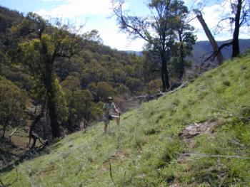 |
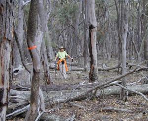
For those of you who like climbing this rogaine has been made to order. Overall the terrain can only be described as rugged, but as well as those pesky orange and white triangles, your climbs are rewarded with stunning views from the ridges and your descents with beautiful strolls in the larger creek and river valleys. There is a sparse network of roads and fire trails offering straightforward (if low scoring) access to the major segments of the course, but very few other tracks. | |||
|
The cleared farmland has many more and less distinct wheel tracks - most of which are unmarked. As long as you're confident you and they are heading in the required direction they can be very useful. However, the lack of undergrowth and the detailed 10m contours on a quite accurate terrain base map allow for reliable navigation "in the rough" - provided you're paying attention. In a couple of areas, repetitive terrain features could make it interesting to re-orient yourself if you lose the plot. |
||||
|
The course setters, Phil Whitten , Belinda Bright and Alexa McAuley, have used the quite distinct but more complex and subtle terrain features to good advantage to provide a significant proportion of controls which will be navigationally challenging. Route choice, both between individual controls and through the overall course is quite broad. Conservative upfront route planning, taking into account team fitness and navigational ability, will be crucial in getting a good return on the effort expended. |
 |
|||
| Top of Page | ||||
"Lost" TeamsThose who participated in the Turon Gold Rush Rogaine were probably aware that we “lost” a couple of teams. Richard Smyth explains how it all happened. Could it happen to you and what would you do in the same situation? We, a team of 3 have been Rogaining for about 7 years, (but some of us bushwalking for many more) and this is the second or third time we have become “lost”. This time circumstances beat us and we did not get back in time. Perhaps it was the team number 13 that caused our problem. We learnt a lot and have decided to pass on our hindsight to help others, hopefully to avoid the same problems. First we have to say thank you to the 3 people who found us (both missing teams) at about 6am, after being out all night looking for two teams. At that time, nearly first light we were packing up ready to back track to where we had gone off track and find our way back from there with the help of daylight. The rescuers showed us where we were, (about 500 metres ENE of CP 62) and out of bounds too. We also regret the concern we caused to all officials, but this is what happened, a rather embarrassing episode. We had marked up a flight plan (with a few extras thrown in if we had spare time), but now realise it would have been better for those searching to have actually plotted just our base course. (The red markings on the course map were relatively heavy and made reading the contours and other features on the map difficult, especially at night). It should have been possible for us to at least do our base course
in the set time. We were on time with possible a bit to spare, until
we hit the “track” (up the hill from 100) that ran from CP 60 down to
43. The “road” on the map turned out to be a gap in the bush along the
ridge, but a very rough rocky course underfoot that one of our team
found huge difficulty in coping with. Instead of the 30 minutes
allowed in our course plotting it took over 90 minutes. At the bottom of the track we met a young couple (Team 110) who compared to us were relatively inexperienced and who decided to travel with us. However at the end of the “road” not all members in the teams were involved in determining our location and while uncertain, we set off in what turned out to be initially a logical but eventually a wrong direction along a creek that turned out not to be the one on the map. We did not realise this until we had travelled for a while, and by then… After coming to a junction of creek and river bed, we ended up in a river bed, not knowing exactly where we were so we climbed up onto a clear spur to try to work out where we were. From observations as we walked, from the map and topography silhouette we confirmed we had travelled north (instead of south) following the wrong creek, and we should back track south to where we had started from by retracing our steps following the creek line etc. However at that time (about 8.30pm) we all needed food and a rest. An attempt was made from the ridge above the spur to phone the emergency number but there was no connection available on Vodaphone. The rest of us had left our Telstra mobiles at base camp. Next time we will take them. In one way we were lucky, the grass was still wet from the rain, and given we found bare ground under a tree, with rocks to make a fire place and enough wood to start a fire, (with the aid of the emergency candle and matches) we felt it was safe to light a fire to warm us up, heat the baked beans and to act as a beacon if anyone was looking for us. We were not short of food and had a good meal with enough left for another. After the meal it was agreed we should sit/sleep the night out and then find our way back with the aid of daylight. We had found enough wood to keep the fire going all night, and we stoked it up in between intermittent sleeps. Through the night we could see lights flashing round the hills as others successfully navigated the course. We learnt that older of the cheap space blankets that 4 of us had, ripped very easily and would have been useless if it had rained or been very cold. We also learned that the more expensive space blankets caught fire easily. We were lucky it was a relatively warm but windy night and it did not rain at all, otherwise we might have moved out earlier. It was unfortunate that the searchers did not know the teams were together until they found us all at 6am, finally attracted by our fire. Given they had been up all night, they were very generous to us and advised us to walk south past our start point to find the Hash House. It was easy in daylight and we got back about 11 hours late, but in time for a hot breakfast. It was interesting countryside, and overall a very well planned and organised event. We will be back for the next one, we will take more care, be better prepared, and will finish on time. |
||||
| Top of Page | ||||