Newsletter Highlights |
|
|
Issue 104 - July 2004
The President's Report ~ July 2004 |
|
|
I hope you all enjoyed the Paddy Pallin 6 hour rogaine on 20th June. All 660 of you! Great turnout, good course, nice country, fine weather, pleasant campsite, delicious food. Given that most of our readers were there, what more can I say, except a big thank you to organiser Trevor Gollan and ALL his team. See reports, results and pictures inside, and on our website.
Two weeks afterwards, several of our members took part in the 2004 Wilderness Rescue Navigation Shield - for those in the two day event that meant 29 hours out in the bush. I understand it was held up at the north end of Wollemi National Park. As well as several teams in the 'Rogaine' class, there were a number of our members competing for the Navigation Shield in Class 1. Usually there is a tussle for first place between Newcastle Bushwalking Club (led by Wil de Sain) and Sutherland Bushwalkers (Peter Wherry and friends). But I got a surprise when I looked at the results and saw neither in first place. Instead it was won by NPWS Blue Mountains - team led by rogainer Tony Garbellini - okay, not such a surprise then! I look forward to hearing more about that event from you guys in due course. After competing a couple of times myself, I know there's always a story to tell. This year, I had a good excuse for not being there: on that same weekend, I was off to South Australia for the BIG event in the Australian rogaining calendar, the 2004 Australian Rogaining Championships. More about that later.
Quote of the month:This month, a poem. To me, the image it conjures matches my experience last weekend at the Australian Rogaining Champs. Think Flinders Ranges. Extract from Wandering on Mt Chung-nan by Meng Chiao (751-814)
NSWRA mattersWe welcome another new member to the committee, Graham Millar, who is taking on the task of publicity coordinator. Graham will work with the committee and event organisers to promote rogaining. We need to maintain freshness and vitality in the sport by bringing in new faces. Also, media visibility gives us an opportunity to acknowledge the contribution of our supporters, such as the landholders, whose cooperation we depend on. Alan Mansfield and I attended the Australian Rogaining Association AGM, held prior to the Australian Rogaining Champs in SA. I will just mention two issues which were discussed (I am happy to provide full details to anyone who is interested). First, the ARA Treasurer, Richard Robinson, has been successful in getting a much better deal for us for insurance. Last year's big increase in premium was a shock to our finances; but now a more reasonable premium has been negotiated. Second, I am chairing the ARA Technical Subcommittee, which is charged with conducting a review of the rules and technical standards over the next few months. Please, if you have any comments or suggestions on these matters, let me know (m_d.hotchkis@optusnet.com.au). Mike Hotchkis |
|
Planning Your Rogaine
Everyone has their own way of filling the three hours between 'maps' and 'Go'. We all know we have to hydrate, carbo load, rest, pack and repack six times, debate how much water and thermal gear to carry, go to the loo six times, compare weights of packs and sneak a look at other people routes but how do you actually go about the main task which is route planning? This is a way that works for me.
Step 1. Mark up the map- course corrections, course setters notes and highlights.
I find that highlighting the controls makes it easier to plan, however you may actually cover some vegetation colouring by doing this. You can avoid that to some extent by marking the number rather than the control. I definitely highlight the water drops because they are hard to find easy to miss in the planning and in the dark. I try to put the important notes from the course setter on the face of the map, eg. if he says this control must be approached from the west I may put an arrow on the map or if there is thick vegetation east of the watercourse I may put an arrow and a bubble message on the map.
Step 2. Join and cover the map, notes and control descriptions on the back.
Before doing major planning I like to join the sheets and cover the map, putting the control descriptions on the back. Some times course setters notes can go on too but if they go over one page there may not be room. Sometimes I get my partner to put one page on his map and I put the other page on. I use cheap covering because it goes on better, because it is thinner and less sticky. If you tape the map to the board or the car bonnet it makes it easier. Cut the sheet to the right size, (2cm oversize) then start it along the short edge and don't stretch the sheet sideways as you start it. Smooth it out from the middle with a handkerchief.
Step 3. Get the big picture by looking for major high ground and water courses
I like to get a good overall picture in my mind. Some people are really quick at this and others struggle. If you mark with a 'white board marker' the main river system(s) and the main high ground(s), it can give you a good feel for the general shape of the course. * If you then look at the controls in the major areas you can get a feel for the overall pattern eg. 'There is high ground to the north east with quite a few high point controls but lots of big climbs... the South is open forest and farms and there seems to be reasonable points but on average about 2km between controls... The north looks confusing for navigation and the vegetation is unpredictable being national park.' * using a white board marker on your contacted map allows you to easily rub it out and try various options.
Step 4. Mark obvious routes starting at the edges
Before you make any decisions, mark any obvious grouping of controls. These are usually found round the edges of the map. Your reasoning should be, 'If I am going to that one then I have to have come from here and therefore I must go there next' or ' While I'm there It makes sense to get that one and that one'. Other obvious routes are on the high ground and the low ground, minimising climbing and descending. Always look for routes that connect controls of similar altitude. Don't make the mistake of spending a lot of time at this stage working out the best route between '47' and '52' That small detail should be worked out later.
Step 5. Have a close look at routes-in and routes-out of HH
Your route home has to have flexibility. There are basically two ways to do this: straight in along a feature with optonal side trips to controls or the wheel route with the option to cut down a spoke to HH at each control. Each method allows you to recalculate your run to home after each control and gives you the option of shortening the distance. Remember that to get maximum efficiency you need to be scoring points all the way. It is no good to have a direct route home for 8km with no time for any side trips to controls. This means that you have walked that 8km for nothing!
Step 6. Join up the obvious routes to minimise altitude changes
Now is the time to start making decisions. Start by joining the obvious routes. Mark in alternatives. I find that this is good time to start consulting with partner. He or she will have some alternatives and some route segments that you will have missed. You can discuss possibilities and come to agreement, hopefully!
Step 7. Estimate total distance and reasonable limit for the team
This step is about selecting the most efficient part of the course to suit your ability. You should estimate how far you reckon your team can walk in the time. Top teams can cover up to 90km on an open 24 hr course but the average for a good team is probably about 50-60. This means that you will walk on a good day at about 2km/h. (including stops) This is likely to be more like 3km/hr in day and 1km/hr at night.
Obviously this increases with the openness of the course and the number of tracks available and your capability. Using the estimate of the distance you are capable of, select the route segments that match this and maximise your points.
Step 8. Refine routes based on points per km, check water intervals
You can also now use the points per km formula to decide whether it is worth going to a particular control. If you decide you can do 50km, and if the route you have selected is 2000 pts then your planned rate is 40 pts per km(2000/50) or 80 pts per hr (2000/24). Therefore if you have to travel over 2km or 1 hr to get an 80 pt control you are on the limits of effectiveness. Check that you have enough water capacity to get between water drops. Don't get too fussy now or you'll run out of time for that last banana and yogurt milkshake. The hard work is done.
Step 9. Permanent pen the map and fill out the intentions sheet.
I then mark the map with a 1 cm long thin line with a permanent texta, slightly to the side of the direct route between each control and rubout the white board marker marks. The alternative is to make a route list of controls on the back or side of the map. All that is left to do is work out the plan to the first control or two and try to convince your rivals that they've got it all wrong!
Dave Jones
David has been rogaining for over ten years and his long time rogaining partner is Glenn Bridgart from ACT. Dave confesses to being 52 and accuses Glenn of being 55, he thinks!! They have won both ACT and NSW Veterans Championships together. He has offered up this article to share his opinions on how he approaches our sport. Hopefully, this will spark some interest from other competitors willing to share their secrets to successful rogaining.
A Day in the Life of a Course Setter .... |
||
| I wake and realise it is daylight. My clock tells me it is a quarter to seven, fairly early for me. I'm not an early riser. I'm warm under a doona in a Scone Hostel bunk and don't fancy the next few hours before the day warms up. | ||
|
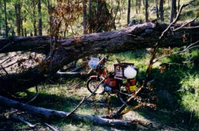
Breakfast over I tackle the preparations for another day of searching for control sites. This is my fourth day this trip. One job is to fix a dressing of sorts on a biggish graze on my left arm. Some time ago I had a bright idea that I would get a motor bike to take me up the 4WD tracks that lead deep into the properties that make up the course area for this year's NSW Championships. I knew about these tracks after setting the course on this same area for the 2000 Australian Championships. I also remembered how much time and energy could be expended "getting in and getting out" from the more distant sections. So round to the local dealer and after a wait of only a week they come up with a Honda "Postie Bike" in the agricultural model that has an extra set of gears. Just what I needed. I used it successfully on a previous trip and on the first day of this trip. |
 |
|
| The second day I went up a track I had walked recently. Going up was OK. Coming down was different. The combination of a steep slope, gravel, stones and my inexperience led to a broken brake lever and the grazed arm.
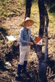
Among the more mundane hazards faced by all rogainers are grass and weed seeds. There hasn't been any rain worth mentioning for three months in this area. It is only lightly grazed so there is plenty of long dry grass and the seeds that go with them. Despite all the protective armour I have been wearing they still get in to stab me in all sorts of places and have to be labouriously plucked from clothes and shoes. I make a mental note to improve my armour before the next trip. I had decided the previous evening to continue to work in the same area this day so my map was ready to go. Check out the other gear like marker plates and wire and off I go, this time in the Camry. The Honda can have a rest for a while. I work by first doing an "armchair" set where I try to pick out likely looking control sites spaced out just so. My first one of these today is one of the group of three or four controls that will be the first visited by the competitors on the day of the event. These controls need to be placed to try and get a fan out of the teams immediately after the start. I've picked a spot which the map shows as having an unusual gully structure. As is so often the case however, when I get there the reality is very different. The actual structure lacks the detail the map shows. However a look around the general area does show up a very promising parallel gully structure that the map doesn't show properly. A reading from my GPS at the top and bottom of each gully and I soon have an accurate watercourse pattern drawn on my mylar. The contours can be corrected later. This is only lightly timbered cattle country so about the only place that a flag would not be seen for 500m in most directions is in one of the deeper gullies. The other problem is finding a suitable tree or shrub from which the flag can be hung. Luckily one gully had a tree with a well placed branch. This event is all on private property and today my planned route will take me for part of the way along the boundary between two properties. Setting an event on private property against a State Forest or National Park introduces some interesting factors for a course setter. You first have to obtain "Property Maps" that show the extent of each property and then get the permission of each owner to include their block. It is at this stage that you find out that most owners are not at all certain just where their boundaries are on a map. They can take you out there and point to fences which they accept as being the boundary but when you show them the property map they will usually be unable to relate it to their fences. There is a very good reason for this. Like most NSW rogaines, I am using a 1:25000 topographic map as my base map. You can buy them at your local newsagent or outdoor store. If you look at one you will see that as well as the contours, watercourses, roads and other features needed to navigate by, it contains "cadastral" information. The map is showing the small "portions" into which most of NSW was subdivided between 1860 and 1880. This big burst of subdivision was a consequence of the Robertson Land Laws of 1861. This was a grand plan to make Crown Land available to the rapidly growing number of free settlers. For one pound per acre they could select a block anywhere out of town of between 40 and 320 acres. It seems there were two ways this happened. You either picked your portion from a plan in a Sydney Government Office or you went to an area that was up for grabs and picked a likely looking block on the spot. This process led to these people being called "Selectors". |
||
 |
Editor's Note:
I"ll bet you didn't see any sights like this way back then. |
|
| Either way they often arrived ahead of the government surveyors and disputes arose between themselves and the squatters who were already there as to who owned what. The surveyors were faced with an almost impossible task keeping up with the demand to peg out all these small portions. One interesting trick of their trade was to align most of the blocks to magnetic north-south and east-west and so greatly reduce time spent on calculations. Ignoring the small drift in the earth's magnetic field since around 1880, these cadastral lines give you handy magnetic north lines if you are using a map with them still on. For my events I make it even easier for you by rotating the map to magnetic north-south and deleting the clutter of the cadastral data.
While the objective of the Robertson Act of having tens of thousands of happy farmers each with their 100 acre block may have been admirable, the reality of course was that it was an impossible dream. Even in a good grazing area such as that in which I am working, it is hard enough to make a living with 10 thousand acres. The selectors soon found you could not support a family on 100 acres. The only way to do it was to rob your richer neighbours and so the act became largely responsible for the big increase in bushranging over this period. The Kelly family is a well known example of selectors who took up bushranging. After battling against the odds, towards the end of the 19th century the selectors gave up and either sold out to adjoining land owners or had their blocks resumed by the banks to whom they were in debt. The Parish Maps of the time give a graphic display of the situation. The end result of this shake up is the more realistic sized properties of today. The only visible legacy of the selectors blocks is the jagged edges of these present day properties that zig-zag their way across the landscape. I often come across the remnants of old fences that line up with the dashed purple lines on my map that mark the legal boundaries. These remnants show that the early owners had the boundaries accurately surveyed and fenced. To hell with the creeks and hills that got in the way. Somewhere near the middle of the 20th century when these first fences needed replacing, it is apparent there was a widespread agreement between adjoining landowners to 'adjust' the fence lines so they were easier to construct and maintain. It was done on the basis of you can have that bit of mine if I can fence in that bit of yours. The makers of these deals have mostly long since departed the properties or died leaving current owners who, as I said earlier, can point to where the boundary fence runs along that ridge over there but can seldom point to where this is on a map or where the legal boundaries lies. What you do find out when you talk to them is they would like to know. Not surprisingly they are interested in whose ahead in the "a bit of yours for a bit of mine" deals of bygone years. So I have taken to plotting in fences wherever I go. The 10m accuracy of a hand held GPS fits comfortably with the 1mm = 25m scale of the map. Nowhere near survey accuracy but plenty good enough for rogaining purposes and for giving the landowners something to peruse. My plotting today shows a typical situation where the fence it suits me to follow runs along a ridge, cutting across the zig-zag dashed purple lines on my map. The fence runs out onto a large relatively flat area and onto a "purple" corner. It then actually runs for about 100m along the purple line! I think about making the corner post a control point. The description could be "The Cadastral Corner". It's a pity the fences won't be on the map you get when you enter the event. So after an enjoyable lunch break I push on to the next "armchair" site. This one is a spur. Spurs present their own set of problems. In this country the light vegetation often means a flag could be seen for miles around. Another is deciding just where you are. Contour lines can often show a significant change in the slope of the centre line of the spur at a particular point. The setter and the competitor can use this to locate by. Today I've found a good one with just the right trees and shrubs to hang the flag without it being too visible. There is also a change in slope perhaps even more pronounced than the map indicates. A short consultation with the Garmin Oracle confirms the position. A slight adjustment of the contours and I've got another one set. By the time I reach the next potential site it is getting late. This is late May and the days are short. I've learnt from past experience to be wary of "Sundowner" controls. You are anxious to get another one done before you give up and head back but being tired and in a hurry can lead to errors which you have to come back later and fix. This spot has a useful set of small but deep gullies running into a bigger watercourse. There are a number of good control sites. I pick on one and make a mark where I think I am on the map. A walk up and down parallel to the main gully shows as is often the case that there are more side gullies than the map shows. This is a similar situation to my first control today except that this is open forest and not so steep. You can't see the gullies till you are near them. Having an accurate mapping of each one and how they line up with ones on the opposite side of the main gully is important. I've just got time to achieve this before dark. I have my headlamp with me and know I'm not far from a road. An hour's steady walk brings me back to the Camry and another 20 minutes back to the hostel and a welcome hot drink. A meal, a write up of the day's events and that's another very enjoyable day over. Graeme Cooper |
||
| Top of page | ||